
Chapter 2: How GIS Works
Adapted from Campbell and Rosenfeld, respectively.
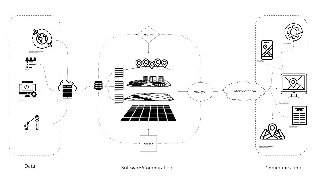
Geographic Information Systems (GIS) allows us to transform our geospatial thinking to answers by layering data and conducting complex analyses to produce in-depth understandings of place. A geographic information system is made up of computer software, a collection of computer hardware, services distributed and accessed via the internet, and tools, but GIS is also a science. It’s used in research and business.
Data
Geospatial data refer to the real-world geographic objects of interest, such as streets, buildings, lakes, and countries, and their respective locations. In addition to location, each of these objects may also possess certain traits of interest, or attributes, such as a name, number of stories, depth, or population; GIS links the two types of data, raster and vector, together to create information and facilitate analysis.
These data can come from a range of sources. It can be collected through terrestrial surveying, or above ground by using remote sensing technologies or LiDAR. Remote sensing refers to collecting data from afar. This is typically achieved through cameras, videos, and sensors attached to aircraft including airplanes, satellites, and drones. It allows us to gather information about the Earth’s surface and track landscape change over time.
Hardware
Computer, memory, storage, scanners, global positioning system (GPS) and other physical components, might make up hardware. The configuration of these hardware can vary widely in size. Although most of us work from a single terminal or laptop that leverages cloud services and tools, if the computer is situated on a network, the network and servers can also be considered an integral component of the GIS because it enables us to share data and information that the GIS uses as inputs and creates as outputs.
Tools
As a tool, GIS permits us to maintain, analyze, and share a wealth of data and information. GIS is actually a collection of tools that can be leveraged for a given geospatial question. From the relatively simple task of mapping the path of a hurricane to the more complex task of determining the most efficient garbage collection routes in a city, GIS is used across the public and private sectors. It’s not just a tool to analyze data, it’s also a tool to represent insights. Aside from traditional paper maps and presentations, through online and mobile mapping, navigation, and location-based services, GIS is personalizing and democratizing geospatial technology by bringing maps and mapping to the masses.
Software
GIS consists of a special type of computer program capable of storing, editing, processing, and presenting geospatial data and information such as maps. The most well-known GIS software provider is Environmental Systems Research Institute Inc. (Esri), which distributes a suite of software called ArcGIS, but there are many others including open-source, community-built software such as QGIS; these are both examples of desktop software with a graphical user interface (GUI). There are web-based software as well, such as ArcGIS Online (AGOL) and CartoDB. All GIS software, regardless of vendor, consists of a database management system that is capable of handling and integrating two types of data: geospatial data and attribute data. That said, it is also possible to work with geospatial data using programming languages such as R and Python; although on their own the capabilities are limited, combined with other tools, they can be very powerful.
|
SOFTWARE |
DESCRIPTION |
PLATFORM |
SOURCE | LANGUAGE | ||
|---|---|---|---|---|---|---|
|
d3 |
Javascript library for data visualization, including maps |
Code |
Open |
Javascript |
||
|
Folium |
Python library to prepare interactive maps for Leaflet |
Code |
Open |
Python |
||
|
Geemap |
|
Code |
Open |
Python |
||
|
Geopandas |
Library to make working with geospatial data in python easier. |
Code |
Open |
Python |
||
|
GeoServer |
Allows users to share and edit geospatial data. |
Web server |
Open |
Java |
||
|
GRASS GIS |
Geospatial data management, vector and raster manipulation |
Desktop |
Open |
GRaphics Symbiosis System (GRASS) |
||
|
gvSIG |
Mapping and geoprocessing with a 3D rendering plugin |
Desktop |
Open |
Java |
||
|
ILWIS |
(Integrated Land and Water Information System) Integrates image, |
Desktop |
Open |
C++ |
||
|
IPyleaflet |
Python library to build interactive maps combining jupyter notebooks |
Code |
Open |
Python |
||
|
OpenJUMP |
Formerly known as Java Unified Mapping Program (JUMPGIS), a Java based vector and raster GIS and programming framework.Current development continues under the OpenJUMP name |
Desktop |
Open |
Java |
||
|
Leaflet |
Build interactive maps using javascript |
Code |
Open |
Javascript |
||
|
LiDar |
Python library to visualize LiDAR and make DEM |
Code |
Open |
Python |
||
|
MapGuide Open Source |
Runs on Linux or Windows, supports Apache and IIS web servers, |
Web server |
Open |
Java, Javascript |
||
|
Mapnik |
C++/Python library for rendering – used by OpenStreetMap. |
Web server |
Open |
C++, Javascript |
||
|
MapServer |
Written in C. Developed by the University of Minnesota. |
Web server |
Open |
C |
||
|
MapWindow GIS |
Free desktop application with plugins and a programmer library |
Desktop |
Open |
C# |
||
|
QGIS |
(previously known as Quantum GIS) Powerful cartographic and |
Desktop |
Open |
Python, C++ |
||
|
RGISLib |
Remote sensing Python library |
Code |
Open |
Python |
||
|
SAGA GIS |
(System for Automated Geoscientific Analysis) Tools for |
Desktop |
Open |
C++ |
||
|
uDig |
API and source code (Java) available. |
Desktop |
Open |
Java |
||
There many great open-source tools for mapping and working with geospatial data. The workbook will focus on QGIS which is a robust GIS platform with a GUI.
Exercises
Exercise 2: QGIS installation exercise

Go to The QGIS web site and download the latest, stable version. Please note, the version you download may be more recent than the version used in this textbook, but you should be able to adapt. Remember, if you can’t find the operation, you can always ask the internet. There are many, many resources to help you through.
